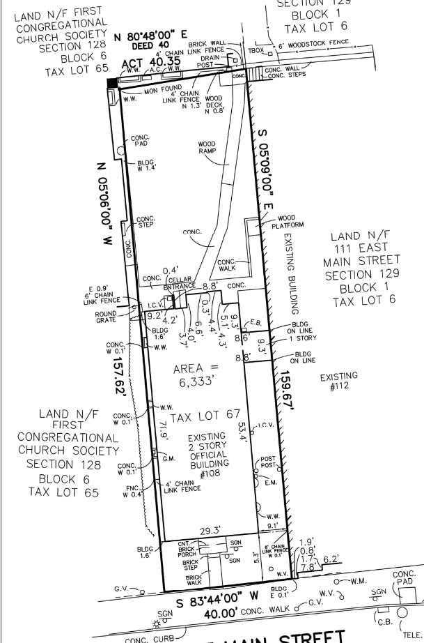
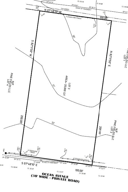
Boundary Survey
We provide complete boundary and title surveys for residential and commercial properties, delivering clear, legally defensible data to support transactions, permitting, and design. Surveys include a detailed analysis of public record documents, on-site conditions, and visible improvements.
- Boundary line locations based on deed and map research
- Easements and rights of way identified and documented
- Location of buildings, patios, fences, and other structures
- Analysis of record documents including deeds, tax records, and adjoining parcels
- Flagging of wetlands and identification of nearby water bodies
Topography
Topographic surveys provide the granular elevation data essential for design, drainage, and environmental permitting. Our surveys are accurate, field-verified, and referenced to current datums—ready for submittal to agencies like the Department of Environmental Conservation (DEC) and Suffolk County Department of Health Services (SCDHS).
- Elevation data tied to NAVD 88 vertical datum
- Existing contour mapping with spot elevations
- Elevations of improvements including driveways, patios, and walls
- Prepared to meet requirements for DEC and SCDHS review
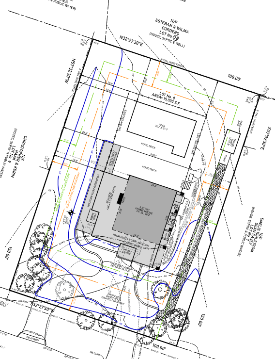
Site Plan Development
Site plans combine existing conditions with proposed improvements for permitting and design. We produce zoning-compliant plans that support municipal approvals and coordinate with engineering teams on grading, utilities, and drainage strategy.
- Integration of boundary and topographic survey data
- Layout of proposed dwellings, additions, pools, patios, and driveways
- Zoning analysis including setbacks, lot coverage, and clearing
- Grading plans and surface drainage strategy
- Existing and proposed utility mapping including septic coordination
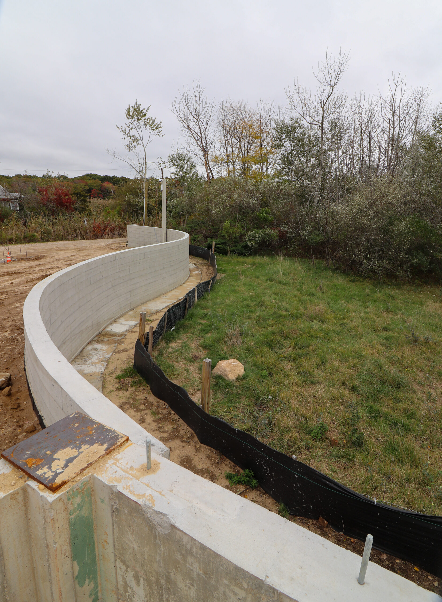
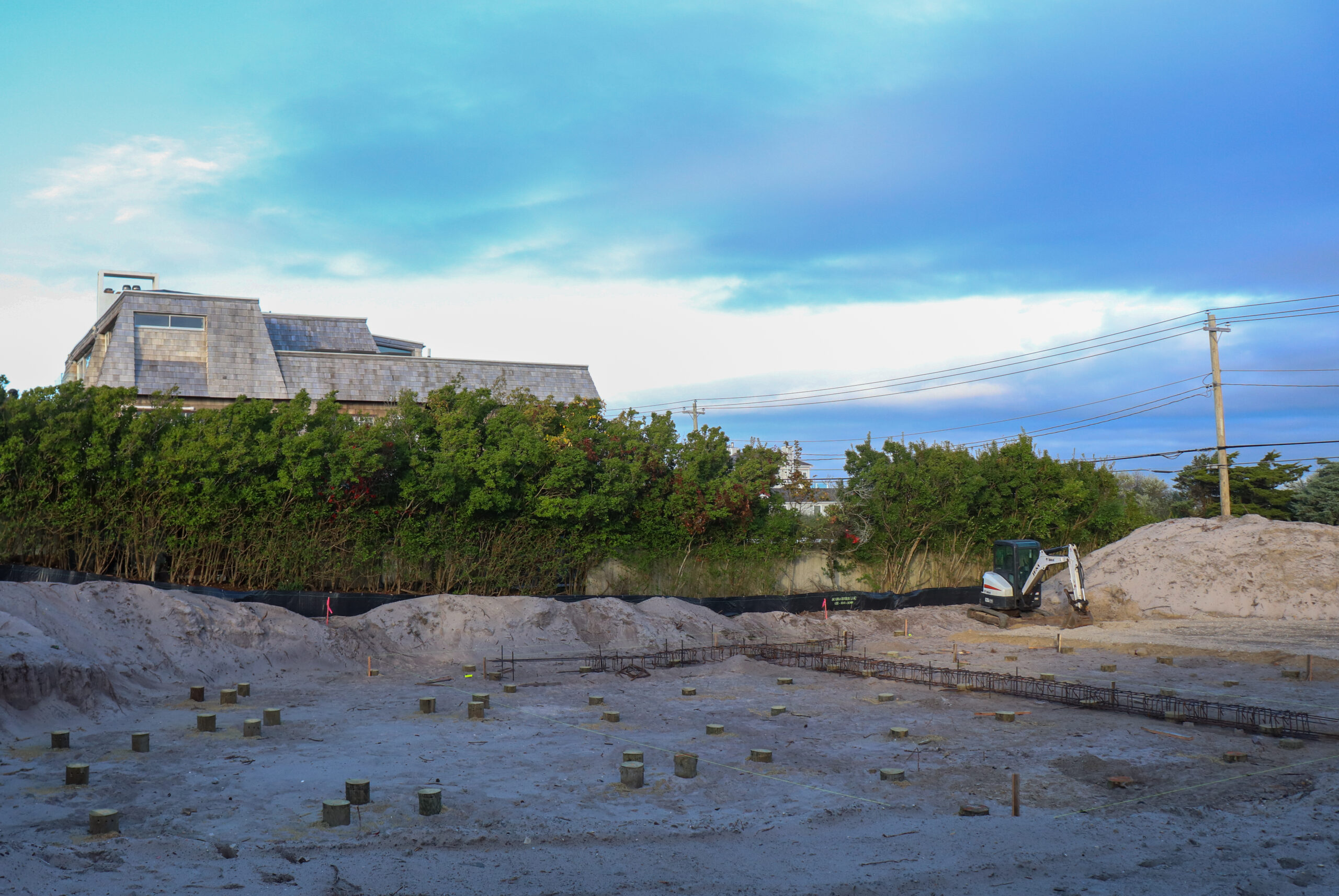
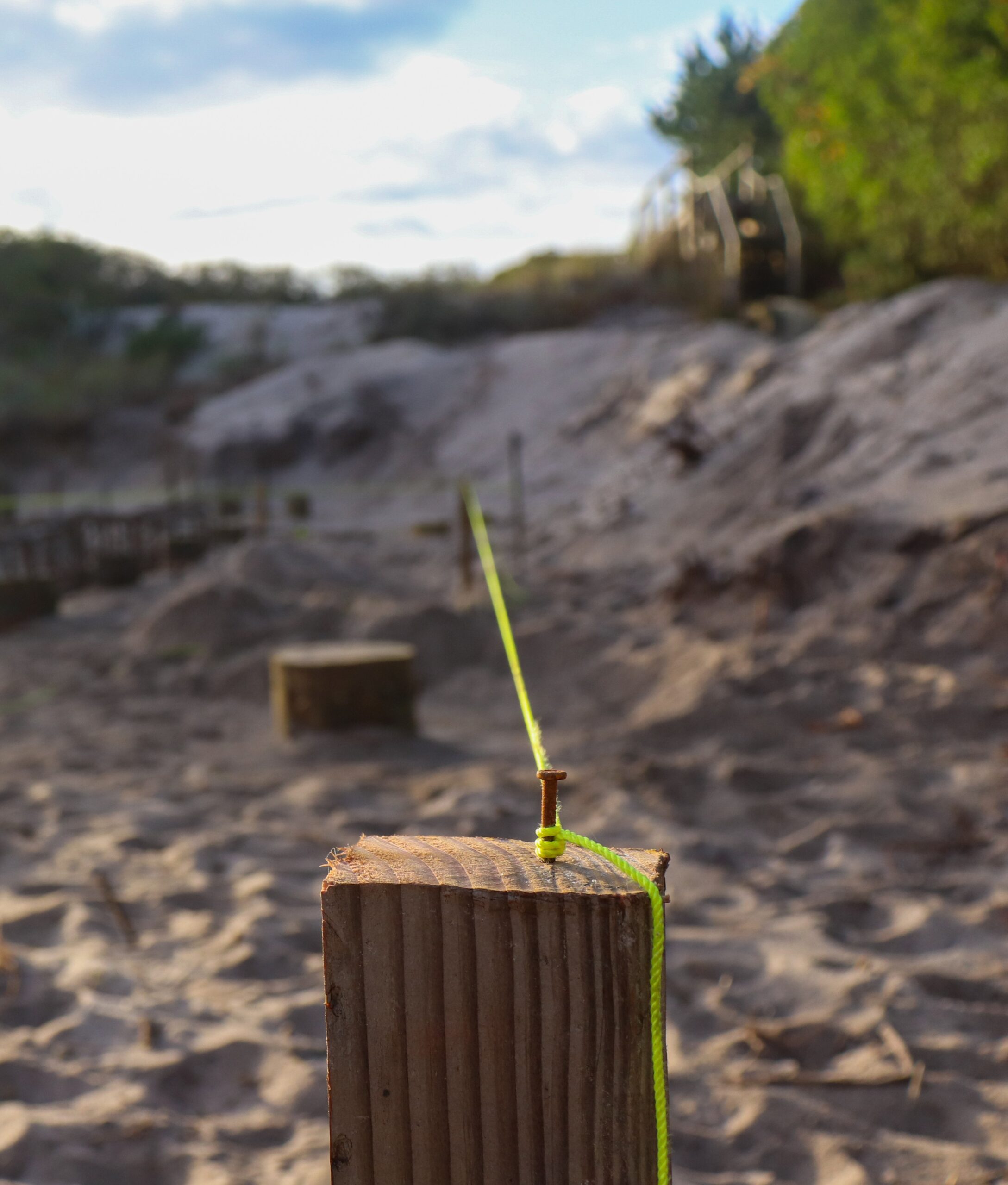
Construction Stakeout
We provide a full range of construction stakeout services to guide site development and ensure precise placement of all critical elements. Our team works closely with contractors to align field conditions with design intent.
- Staking of clearing boundaries to mark areas for permitted tree and brush removal
- Foundation staking including pile and footing locations
- Property line establishment for fencing and setbacks
- Layout of pools, driveways, patios, and other improvements
- Steel and anchor bolt layout for structural coordination
FEMA Certification
We prepare FEMA Elevation Certificates using precise survey methods to determine site and structure elevations- essential for flood insurance, coastal development, and regulatory compliance.
- Highly accurate elevation data for buildings, basements, and site features
- FEMA-compliant certificates for insurance or municipal submittal
- Required for new construction and major reconstruction in coastal areas

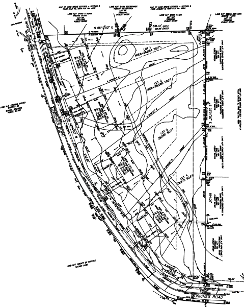
Subdivision
From feasibility studies to planning board hearings, we support the full subdivision development process. Our team handles everything from code research to map production and coordination with attorneys, engineers, and municipalities for final approvals.
- Existing conditions analysis and site documentation
- Zoning and code research to support layout design
- Subdivision map creation including zoning, road layout, utilities, and easements
- Coordination with project team for SCDHS and municipal approvals
- Representation at planning board meetings through map approval
explore packages
Choose from a range of bundled services tailored to support closings, residential builds, or commercial development.
package #1
title closing survey
A streamlined package designed for property transactions requiring a clear and complete boundary survey. This package meets legal and title company standards, ensuring confidence at closing.
Includes:
- Boundary line locations
- Easements and rights of way
- Mapping of visible improvements (structures, patios, fences, etc.)
- Record document analysis (deeds, filed maps, tax records, adjoining parcels)
- Wetland flagging and delineation (if applicable)
package #2
residential new build/renovation
Tailored for homeowners and architects planning new construction or major renovations. Combines key pre-construction surveys and layouts to support permitting, design, and development.
Includes:
- Existing conditions survey
- Topographic survey
- Proposed site plan
- Stakeout of clearing limits, foundations, and other site elements
- Location of neighboring wells and septic systems (if applicable)
- Utility mapping
- Test hole coordination
- As-built survey
package #3
commercial new build/major renovation
A comprehensive package designed for commercial development and large-scale renovations. This all-in-one solution supports feasibility, compliance, and construction coordination.
Includes:
- Existing conditions survey
- Topographic survey
- Detailed code analysis and feasibility assessment
- Proposed site plan including parking layouts, curb cuts, and access
- Utility mapping
- Test hole coordination
- As-built survey
FEATURED PROJECTS
the das difference

seamless integration
As a surveying practice embedded within a multidisciplinary engineering team-including civil, structural, and MEP-we eliminate disconnects and improve coordination. This tight integration streamlines design, shortens timelines, and reduces costly missteps from planning through construction.

technology driven
From high-precision field data collection to internal workflow management, our systems are built to ensure clarity, consistency, and speed. Every tool we use is chosen to make the process easier-for both our clients and project partners.

Hamptons expertise
With decades of combined experience and access to historical records across the East End, we understand the unique demands of building in coastal and environmentally regulated areas. From wetland buffers to flood zone requirements, that insight informs every survey we deliver-and ensures it aligns with local expectations and permitting standards.
resources
FOR THOSE WHO WANT TO KNOW MORE.
ANY QUESTIONS? WE GOT YOU.
Everything you need to know before selecting the right surveyor and project team.
We focus on the East End of Long Island, including the Hamptons, the North Fork, and surrounding areas within Suffolk County, including Southampton, East Hampton, Shelter Island, Southold, Brookhaven, Quogue and Westhampton. Our team has deep knowledge of local codes, permitting requirements, and environmental considerations specific to this region. We also have access to historical records and prior surveys across these areas, giving us added insight on longstanding property lines, easements, and wetland restrictions.
As the successor to Ken Beckman, we hold decades of subdivision and site planning records that continue to support development across the East End.
An accurate survey is essential for protecting property boundaries, avoiding legal disputes, securing permits, and informing design decisions. It’s the foundation of every successful project—whether you’re closing on a property or preparing for construction.
A professionally prepared boundary or topographic survey ensures that improvements like pools, driveways, or additions don’t encroach on setbacks or neighboring land. It also helps architects, engineers, and contractors work from accurate site data-avoiding costly rework during construction.
Furthermore, a certified survey is typically required for closing on the purchase of a property, obtaining title insurance, and securing a mortgage.
Look for licensed professionals with local experience, a strong reputation for responsiveness, and familiarity with municipal permitting processes. It’s also important to choose a team that uses modern equipment and can adapt quickly to evolving site conditions.
Key factors include availability, responsiveness, and proven technical skill. A reliable surveying team delivers with precision, avoids costly setbacks, and never cuts corners, especially when accuracy and approvals depend on it.
Ask about their experience with Suffolk County Department of Health Services (SCDHS) and DEC coordination if your property involves wetlands or septic design. Choosing a Long Island-based surveyor who understands local zoning and land use constraints can save time during reviews and help avoid permit delays.
A unified team minimizes delays, reduces miscommunication, and ensures that surveying, civil, structural, and MEP considerations are aligned from the start. This integrated approach streamlines coordination and supports a faster, more efficient build process.
When your surveyor and engineers are part of the same team, field data flows directly into design-minimizing translation errors and RFIs. Stakeouts reflect that alignment, ensuring layouts are accurate, timely, and consistent with approved plans. It also ensures that proposed site plans, grading strategies, and utility layouts are developed in real time with accurate conditions, which is especially valuable on coastal and constrained sites.
With integrated services, we also streamline the septic permitting process with SCDHS, allowing us to take full ownership from survey to submission. This results in faster timelines and tighter coordination with structural and civil teams.