Understanding the Role of a Long Island Land Surveyor in Real Estate Closings
In Suffolk County and across the Hamptons, closing on a property typically involves more than signing a deed and transferring funds. Before the title can be transferred and a loan funded, most lenders and title companies require a current land survey prepared by a licensed land surveyor.
Unlike a deed alone, a professionally prepared survey documents the physical and legal realities of a site, including boundary lines, improvements, encumbrances, and potential conflicts between record data and conditions in the field. On the East End of Long Island, where historic subdivisions, lost monumentation, and coastal conditions frequently complicate record descriptions, this clarity is essential.
An updated survey is a risk-management tool. It protects the real estate title, supports title insurance issuance, and verifies that existing conditions align with zoning and regulatory requirements. For buyers, attorneys, architects, and developers, engaging a qualified land surveyor before closing provides clarity at the moment ownership transfers and establishes a reliable foundation for future improvements.
In this article, we examine what a land survey establishes, why it is required at closing, and how boundary determination, encroachments, historic subdivision records, and coastal regulatory constraints shape real estate transactions across Suffolk County and the Hamptons.
What Is a Land Survey
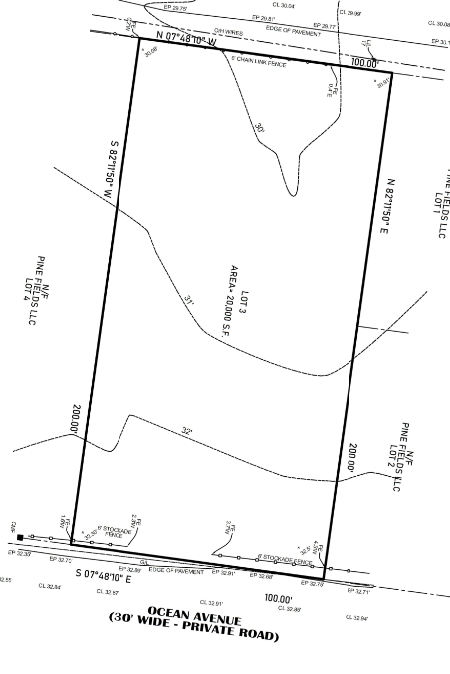
A land survey is the professional boundary determination and documentation of a property’s legal limits, improvements, and encumbrances. In New York, this work must be performed by a licensed land surveyor in accordance with New York State Association of Professional Land Surveyors (NYSAPLS) standards and established principles of boundary determination.
Unlike a tax or GIS map, a survey is the result of record research, field investigation, measurement, and professional judgment. It reconciles deed descriptions, filed subdivision maps, adjoining parcel records, and physical evidence found on site to establish defensible property lines.
A properly prepared land survey identifies:
- Property boundary lines
- Bearings and distances
- Area calculations
- Physical monumentation such as concrete monuments, iron pipes, rods, or markers
- Existing improvements including dwellings, decks, pools, driveways, and fences
- Recorded easements and rights-of-way
- Encroachments or conflicts between record boundaries and field conditions
This is not a copied map or a visual reference. It is a licensed professional opinion regarding the location of property boundaries and the conditions that affect them. That distinction is critical, particularly in Suffolk County and across the East End, where historic subdivision records and aging monumentation often require careful interpretation.

What Does a Survey for Closing Contain?
A survey prepared for closing, often referred to as a title survey or boundary survey, is designed to meet the requirements of lenders and title companies while providing a clear and defensible understanding of the property being conveyed.
Learn more about our Title Closing Survey package and how it supports real estate transactions.
1. Boundary Lines
The foundation of any closing survey is boundary determination. This includes:
- Comprehensive record research, including deeds, filed subdivision maps, and adjoining parcel documents
- Metes and bounds analysis
- Reconciliation of discrepancies between record descriptions and physical occupation
On the East End of Long Island, where older subdivision maps and generational lot divisions are common, record descriptions often require careful interpretation. Establishing defensible boundary lines is a professional determination, not a clerical exercise.
2. Improvements
A closing survey documents all visible improvements located on the property, including:
- The dwelling and attached structures
- Decks, patios, and porches
- Pools and accessory structures
- Driveways
- Retaining walls
- Fences
This documentation allows attorneys and title companies to verify whether improvements are located within property lines and in compliance with setbacks.
3. Easements and Rights of Way
Recorded encumbrances, such as easements or rights granted to others that are filed in the public record, are identified and shown on the survey. These include:
- Utility easements
- Drainage easements
- Access easements
- Environmental easements
- Paper streets versus constructed roadways
Understanding these rights is critical, as easements may restrict future improvements or affect how the property can be used.
4. Encroachments
Encroachments are particularly common in Suffolk County and across Long Island. A title survey will identify conditions such as:
- Fences installed over a property line
- Shared or misaligned driveways
- Structures crossing a boundary or setback line
- Landscaping features or retaining walls extending onto adjoining parcels
When identified before closing, these issues can be addressed through title exceptions, boundary agreements, or corrective action. When discovered later, they can become costly disputes.
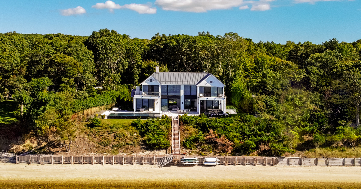
5. Waterfront and Coastal Boundary Features
On waterfront and near-water parcels in Suffolk County and the Hamptons, a closing survey may also document critical shoreline and coastal features that influence both title and regulatory compliance. These elements often define not only how the property is physically occupied but also jurisdictional limits and development constraints.
Depending on site conditions and project scope, a survey may identify and depict:
- Mean High Water (MHW) lines, where applicable, which may represent the legal boundary between private upland ownership and state-owned underwater lands
- Bulkhead locations and alignment relative to record boundary lines
- Top of bluff or top of bank, particularly where coastal erosion hazard areas or setback regulations apply
- Flood zone delineation based on current FEMA mapping, including flood zone designation and base flood elevation data
- Shoreline features such as beaches, tidal wetlands boundaries (as mapped or regulated), and adjacent water bodies
On the East End, shoreline position and regulatory overlays can directly affect buildable envelope, setback compliance, and lender risk assessment. In certain transactions, particularly involving waterfront property, documenting these features provides essential clarity at closing and establishes a baseline condition for future permitting and design.
A properly prepared survey for closing documents boundary conditions, identifies potential encroachments in New York and Long Island, and supports evaluation of the real estate title being insured.

Why a Licensed Land Surveyor Is Required in New York
In New York, boundary determination is a regulated professional service. Property lines can only be established and certified by a licensed land surveyor practicing under state law and NYSAPLS standards.
Determining a boundary requires research, field investigation, evaluation of physical evidence, and application of established principles of boundary law. The surveyor assumes professional responsibility for that determination.
A licensed land surveyor is authorized to:
- Interpret deeds and legal descriptions
- Reconcile conflicting metes and bounds calls
- Evaluate discrepancies between record descriptions and physical occupation
- Re-establish lost or disturbed monumentation
- Analyze historic subdivision maps and archived filings
Across Suffolk County and the East End of Long Island, many properties originate from older subdivisions and legacy conveyances. Descriptions may reference adjoining landowners, historic monuments, or outdated mapping standards. Resolving those conditions requires professional judgment supported by record analysis and precise field data.
Why Deed Descriptions Are Often Problematic on the East End
Across the East End of Long Island, many properties originate from early and mid-20th-century subdivisions, estate divisions, and generational transfers. As a result, deed descriptions are not always aligned with modern surveying standards.
Common challenges include:
- Vague language such as “along lands of Smith” rather than defined bearings and distances
- Descriptions that omit precise directional calls or dimensional clarity
- Historic subdivision maps prepared under older standards with limited field data
- Tax map inconsistencies that do not reflect controlling record documents
- Generational lot divisions that reference monuments or adjoining ownership that no longer exists
In these circumstances, boundary determination requires reconstruction of the record history, evaluation of archived filings, and correlation with existing field evidence. The process often extends beyond a single deed and into decades of subdivision mapping and adjoining parcel research.
Why Surveys Matter at Closing
A survey prepared for closing plays a direct role in the issuance of title insurance and the transfer of real estate title in New York.
Title insurance is a policy that protects an owner or lender against defects in title, including undisclosed liens, boundary disputes, or other recorded encumbrances. Before issuing that policy, the title company conducts a title search to review recorded documents affecting the property. A title search evaluates the public record. A title survey evaluates existing field conditions and boundary location.
Both are required to fully assess risk.
A survey for closing in New York documents the physical relationship between boundary lines and improvements, identifies easements, and discloses potential encroachments. That information allows the title company to determine whether exceptions must be listed in the policy.
When encroachments are identified on a survey, they may be reflected as survey exceptions in the title insurance policy. In certain cases, coverage may be limited or excluded unless the condition is resolved prior to closing. Lenders routinely require a current survey to assess this risk before funding a mortgage.
In Suffolk County and across the East End of Long Island, where boundary discrepancies and improvement conflicts are common, a current land survey supports clean title issuance and reduces the likelihood of post-closing disputes. It provides documented clarity at the point of transfer and establishes a reliable record for future reference.
Suffolk County and Hamptons-Specific Risks
Closing on property in Suffolk County, particularly across the Hamptons and the broader East End, involves site conditions and regulatory layers that are distinct from other parts of New York. A land survey prepared for this region must account for coastal, environmental, and historic development factors that directly affect title, permitting, and future improvements.
Coastal and Environmental Constraints
Many East End properties are subject to environmental oversight at the state and municipal level. Surveys frequently intersect with regulated areas such as:
- Wetlands regulated by the New York State Department of Environmental Conservation, which establish protected areas and required buffer zones around tidal and freshwater wetlands
- Town-regulated wetlands, where local municipalities impose additional jurisdiction and setback requirements
- FEMA flood zone designations that affect elevation requirements, insurance obligations, and building limitations
- Coastal erosion and shifting shoreline conditions that can influence boundary occupation and setback compliance
- Bulkheads, bluffs, and other shoreline stabilization features that impact both property limits and regulatory review
On waterfront and near-water parcels, regulated areas and elevation data are often central to determining buildable envelope, compliance with setbacks, and long-term development feasibility. A current land survey provides the documented field data required to evaluate these constraints accurately.
SCDHS Considerations
In Suffolk County, property development is closely tied to review by the Suffolk County Department of Health Services (SCDHS). Surveys frequently support Health Department evaluation by documenting:
- Septic system locations, including tanks, leaching structures, and separation distances to property lines and wells
- Approved or grandfathered subdivision status, which determines whether a parcel qualifies as a legal building lot
- Health Department approval history affecting new construction, expansions, or system upgrades
Subdivision status and septic layout can directly impact whether a property is buildable or eligible for expansion. A current land survey provides the spatial documentation required to support SCDHS review and future permitting.
Historic Development Patterns
The East End contains dense historic subdivisions and generational lot divisions that predate modern mapping standards. Surveys frequently encounter conditions such as:
- Lots created under outdated subdivision maps with limited dimensional data
- Older parcels that have not been resurveyed in decades
- Disturbed or missing monumentation
- Fence and driveway encroachments between adjoining properties
These development patterns increase the likelihood of boundary discrepancies and occupation conflicts. A land survey prepared with local record familiarity provides a defensible boundary determination at the time of closing.
East End properties are shaped by layered subdivision history, coastal regulation, and Suffolk County health and permitting oversight. Interpreting these factors requires familiarity with local records, municipal standards, and historic filing practices. A land surveyor working regularly in Suffolk County understands how these variables interact and how they affect boundary determination, title review, and future development potential. That local expertise directly influences the accuracy, defensibility, and reliability of a survey prepared for closing.
Planning Beyond Closing: Why Today’s Survey Impacts Tomorrow’s Design
A survey prepared for closing often becomes the foundation for future design and permitting. For architects, developers, and property owners planning improvements, accurate boundary and existing conditions data is essential long after the transfer of title.
A current land survey supports:
- Zoning setback verification to confirm required front, side, and rear yard compliance
- Lot coverage and clearing calculations used in municipal review
- Feasibility analysis for additions and vertical expansions
- Pool placement relative to property lines, wetlands, and septic systems
- Accessory dwelling unit (ADU) planning and code compliance
- Site plan development integrating grading, drainage, utilities, and access
Across Suffolk County and the Hamptons, zoning limitations, wetland buffers, and Health Department requirements frequently constrain the buildable envelope. A survey completed at closing can transition directly into topographic mapping, zoning analysis, and engineered site planning.
When surveying is integrated with civil, structural, and MEP engineering, field data flows directly into design documentation. That coordination reduces duplication of effort, shortens permitting timelines, and supports more informed development decisions from the outset.
To understand how integrated surveying and engineering accelerate project delivery across Suffolk County and the Hamptons, explore DiLandro Andrews’ civil, structural, and MEP engineering services.
Land Survey Cost and Scheduling in Suffolk County
The cost and timeline for a land survey in Suffolk County vary based on site conditions, record complexity, and project scope. A survey for closing requires both documentary research and field verification, and the level of effort depends on several factors.
Cost Drivers
Survey cost is influenced by:
- Property size, including overall acreage and boundary length
- Waterfront complexity, where bulkheads, erosion lines, and regulated areas require additional coordination
- Density of improvements such as dwellings, pools, patios, retaining walls, and accessory structures
- Quality and clarity of record documents, including deeds and filed subdivision maps
- Availability and condition of existing monumentation in the field
Closing survey costs in Suffolk County generally range from $1,000 to several thousand dollars, with pricing driven by site conditions, improvement density, and record complexity.
Timeline
Scheduling is similarly dependent on scope and existing documentation. In many cases, surveys in Suffolk County require:
- Three to eight weeks from authorization to final deliverable
- Additional time during winter conditions or periods of limited field access
- Coordination with attorneys and title companies, as the survey often becomes a gating item in the closing schedule
At DiLandro Andrews Surveying, standard residential closing surveys are typically completed within approximately two weeks from authorization, depending on property complexity and field conditions. This accelerated turnaround helps our clients, including attorneys, lenders and buyers, maintain closing schedules in time-sensitive transactions.
Because a current land survey is commonly required for title insurance issuance and lender approval, early engagement helps reduce the risk of closing delays.
Survey As the Foundation of Ownership
In Suffolk County and across the Hamptons, boundary clarity is not assumed. It is established through documented research, field verification, and professional determination. A survey prepared for closing defines what is being conveyed, identifies conditions affecting title, and provides the verified site data required for future design and regulatory compliance.
At DiLandro Andrews Surveying, this work is performed within an integrated engineering environment, supported by advanced field technology and reinforced by access to historic East End subdivision records that continue to govern present-day property lines. That combination of local record familiarity, technical precision, and coordinated workflow strengthens both the closing process and the long-term viability of the property.
Every successful project starts with the survey. Engaging DiLandro Andrews Surveying early in your transaction reduces the risk of closing delays, limits exposure to boundary disputes, and establishes a reliable foundation for long-term ownership on the East End of Long Island.